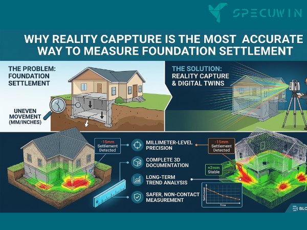
Foundation Settlement is often a silent, slow-moving crisis for building owners. By the time visible cracks appear in the masonry or doors refuse to latch, the underlying structural shifts are often well advanced. Traditionally, monitoring these movements involved manual leveling or plumb-bob measurements methods that, while reliable, often lack the granularity to catch “micro-deflections” before they become macro-failures.
Today, the AEC (Architecture, Engineering, and Construction) industry is undergoing a digital transformation. We are moving from reactive repairs to predictive maintenance through Reality Capture. By integrating high-resolution laser scanning and drone mapping, engineers can now track Foundation Settlement with sub-millimeter precision, providing a data-rich narrative of a building’s health over time.
Understanding the Mechanics of Foundation Settlement:-
Before diving into the technology, we must understand the “why” behind the movement. Foundation Settlement occurs when the soil beneath a structure can no longer support its weight, leading to downward movement. This can be “uniform,” where the whole building sinks evenly, or “differential,” where one part sinks faster than another, creating immense internal stress.
The Limitations of Traditional Diagnostics:
Historically, diagnosing Foundation Settlement relied on visual inspections and mechanical sensors. While a Structural engineer plays a vital role in interpreting these signs, manual tools often fail to capture the “big picture.” A crack in a wall is a symptom, but it doesn’t always reveal the exact pivot point of the structural failure.
How Laser Scanning Identifies Foundation Settlement:-
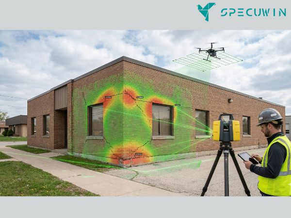
Terrestrial Laser Scanning (TLS) has revolutionized how we perceive structural geometry. A laser scanner emits millions of points per second to create a “Point Cloud” a highly accurate 3D digital twin of the structure.
1. Detecting Micro-Deflections:
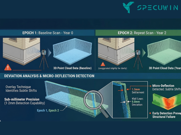
When tracking Foundation Settlement, precision is everything. Laser scanners can detect deviations as small as 1-2mm. By performing “epoch-based” scanning (scanning the same site at different time intervals), engineers can overlay point clouds to see exactly where and how much a wall has leaned or a floor has dipped.
2. Floor Flatness and Levelness (FF/FL):
A key indicator of Foundation Settlement is a sloping floor. Reality capture software can generate “heat maps” from scan data, instantly highlighting areas that have deviated from the original design plane. This provides a visual proof of settlement that is much easier for stakeholders to understand than a table of coordinates.
Drone Mapping: A Macro View of Foundation Settlement:-
While laser scanning excels at capturing intricate details of a facade or interior, drones provide the aerial context necessary for large-scale sites or high-rise structures.
Aerial Photogrammetry and LiDAR:
Drones equipped with LiDAR (Light Detection and Ranging) or high-resolution cameras can map the entire perimeter of a site. This is particularly useful for identifying external factors contributing to Foundation Settlement, such as:
- Poor Site Drainage: Identifying where water pools near the foundation.
- Soil Erosion: Visualizing changes in the landscape that might indicate shifting sub-strata.
- Structural Tilting: Drones can capture the verticality of high-rise buildings, which is a major challenge in structural engineering of high-rise buildings.
The Workflow: From Data Capture to Actionable Insights:-
Diagnosing Foundation Settlement through reality capture follows a sophisticated yet logical workflow:
- Data Acquisition: Drones and scanners capture the “As-Is” condition.
- Point Cloud Processing: Individual scans are stitched together into a unified coordinate system.
- BIM Integration: The point cloud is compared against the original BIM (Building Information Modeling) model. This “Scan-to-BIM” process is transformative, as BIM is transforming consultancy by allowing for precise digital comparisons.
- Deformation Analysis: Specialized software calculates the delta between different time-stamped datasets.
- Reporting: The Structural engineering report is generated, offering a visual and data-backed diagnosis.
Why Reality Capture is the Future of Structural Health:-
The shift toward these technologies isn’t just about “cool gadgets”; it’s about risk mitigation and cost-saving.
Predictive vs. Reactive:
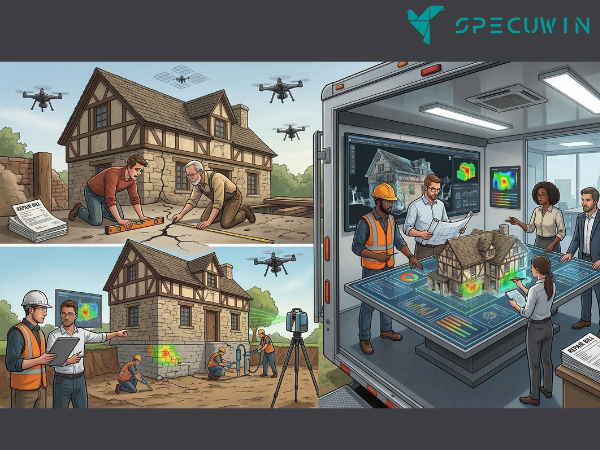
Most Common structural problems in old houses are caught too late. Reality capture allows for “Structural Health Monitoring.” By identifying Foundation Settlement in its infancy, owners can implement minor soil stabilization or underpinning before the building requires a massive, multimillion-dollar overhaul.
Enhancing Collaboration:
When a building shows signs of distress, multiple parties are involved. High-quality digital data ensures that collaboration between contractors and structural engineers is seamless. Instead of arguing over manual measurements, everyone looks at the same high-resolution 3D model.
Conclusion: Securing the Ground Beneath Our Feet:-
Foundation Settlement doesn’t have to be a mystery. By leveraging the power of reality capture, we can “see” the invisible forces acting on our structures. Whether it’s a historic residence or a modern skyscraper, drone mapping and laser scanning provide the clarity needed to ensure long-term stability and safety.
If you suspect your building is shifting, don’t wait for the cracks to tell the story. Utilize modern technology to diagnose the problem with precision.
FAQ’s:-
1. How accurate is laser scanning for detecting Foundation Settlement?
A. Modern terrestrial laser scanners are accurate within 1mm to 3mm. This level of precision allows engineers to detect “micro-deflections” that are completely invisible to the naked eye.
2. Can drones see Foundation Settlement through the ground?
A. No, drones do not see through the soil. However, they use LiDAR and photogrammetry to detect the resulting movement of the structure and the surrounding terrain, which provides clues about the underlying soil behavior.
3. Is reality capture more expensive than traditional structural inspections?
A. While the initial mobilization of high-tech equipment may cost more than a simple visual walk-through, it is significantly cheaper than the “trial and error” repairs that often result from incomplete data.
4. How often should a building be scanned to monitor movement?
A. This depends on the severity of the issue. For active Foundation Settlement, scans might be performed quarterly. For long-term monitoring of a stable structure, once every 1–2 years is typical.
5. What is the main benefit of Scan-to-BIM in this process?
A. Scan-to-BIM allows you to compare the current, potentially settled state of a building against its “perfect” design model. This makes it incredibly easy to see exactly where the structure has deviated from its intended position.
Read More On:-
For more information about engineering, architecture, and the building & construction sector, go through the posts related to the same topic on the Specuwin Blog Page.
Find out more accurately what we are going to take off in the course of applying leading new technologies and urban design at Specuwin.